Authors: Veenhof R. (Oranje-Nassau Energie B.V.) , Moser T.J. *(Moser Geophysical Services) , Sturzu I. (Z-Terra Inc.) , Dowell D. (Z-Terra) , Popovici A.M. (Z-Terra), and Nieuwland F. (SGS-Horizon B.V.)
76th EAGE Conference & Exhibition, Amsterdam 2014.
In 2013 SGS Horizon, in combination with Z-Terra and Moser Geophysical Services, carried out a reprocessing job for operator Oranje Nassau Energie which involved the merge of the offshore survey Q16 and onshore survey Monster. The pre-processing of the data was followed by pre-stack time and depth migration, all steps with amplitudes preserved because of fluid sensitivity of the reservoir. The velocity model involved estimation of anisotropy parameters and confirmed findings of a negative delta in the Tertiary as seen in other parts of the southern North Sea. The construction of a high-quality velocity model created the optimal conditions for subsequent diffraction imaging, which in turn provides high-resolution structural information.
Introduction
In 2013 SGS Horizon, in combination with Z-Terra and Moser Geophysical Services, carried out a reprocessing job for operator Oranje Nassau Energie which involved the merger of the surveys Q16 and Monster. The pre-processing of the data was followed first by a pre-stack time migration and then a pre-stack depth migration. Pre-processing and subsequent pre-stack time- and depth-migration were amplitude preserved since the reservoirs are fluid sensitive. Velocity analysis during the PSDM phase was performed by tomography where three levels were considered: pre-Chalk, Chalk and post-Chalk. Depth migration was performed in anisotropic mode. The availability of a high-quality migration velocity and focusing of the depth image provided optimal conditions for subsequent diffraction imaging and deployment of diffraction imaging technology in the North Sea.
Q16
The working area is in the licences Q16a and Q16bc in the southern part of the Dutch North Sea (Figure 1).
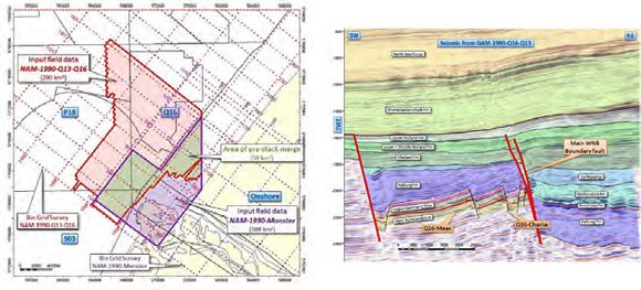
Figure 1 Location of Q16 in the Dutch offshore
The primary target in the area comprises the Main Buntsandstein of the Q16A and Q16- Maas fields including their near-field exploration prospects. The depth range of this target is approximately from 1500–4000m. In addition, the Lower Cretaceous Vlieland Formation represents a secondary target. No sub-salt imaging is required as no movable Zechstein salt is present in subject area. The structural setting is defined by two key tectonic features: pre-Cretaceous block faulting (mainly caused by Jurassic rifting of the West Netherlands Basin) and Late Cretaceous to Early Tertiary basin inversion. The compressional inversion is relative mild in the Q16 area at the southwestern edge of the West Netherlands Basin. Continue Reading →